Love is a smoke made with the fume of sighs. – William Shakespeare
Route 321 brings you south through the highly commercialized towns of Pigeon Forge and Gatlinburg, prior to reaching Sugerlands Visitor Center on the northern edge of the park. A short distance further south and you arrive at Elkmont Campground, my base camp for the first few days. Snuggled between low swaybacked ridges, Elkmont lies married to a small piece of the Little River. I settled in for the night to the sound of slow moving water.
Cades Cove is a 27 mile drive southwest on a sinuous blacktop road, watched over by prodigious age-grayed trees. Little River Gorge Road traces the Little River, held from the two lane road by a graceful stone retaining wall. As you travel east to west, the river is on your left, a twin to your every movement, a mirror of the road. Your eye is constantly drawn to the water as it languidly drapes over boulders, sliding into dark pools and eddies. You feel the movement of the water. You are pulled into the landscape by the river.
THE EVER HYPNOTIZING LITTLE RIVER. I STILL SEE THIS RIVER IN MY DREAMS.
SLIVER OF CADES COVE AS YOU WALK DOWN FROM THE JOHN OLIVER HOME BUILT IN THE 1820’S. I HAD TO WAIT 20 MINUTES TO GET A SHOT WITHOUT A CAR.
Although my ancestors – the Cherokee – never lived in Cades Cove, they hunted and camped there for hundreds of years. Some of the trails where they came down from the mountains to hunt deer, elk, bison and bear, still exist. There are extremely few stories of encounters between Cherokee hunters and the original settlers of the early 1800’s. Abram Jobe wrote that Indians “could be seen prowling around”, and he believed his uncle was killed by a Cherokee while hunting in the mountains. Once a small population emerged (a handful of families in 1821 grew to 132 families in 1821) and a fledgling economy sprang up (farmers, millers, blacksmiths, distillers), the Cherokee moved westward toward new hunting grounds. Shortly afterward – three generations ago – Cherokee blood entered the Smith family.
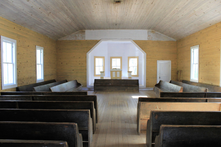
To walk Cades Cove is to step back in time. We were a young nation when people from east Tennessee, Virginia and North Carolina found their way into this high meadow of fertile ground to cultivate and grow crops of wheat, corn and barley. Some grew tobacco and others cotton. From the great meadows filled with game, they culled and sustained their families through winter. There was a sense of community. Neighbors helped each other. Churches were the pillars of the community – the center of everything. As park volunteer Tom stated in his 20 minute talk on the churches and people of Cades Cove, “if you didn’t belong to a church, you were not part of the community. And that was not something anyone could afford.”
PRIMITIVE BAPTIST CHURCH, ESTABLISHED 1827, REBUILT IN 1887. THE CHURCH WAS CLOSED DURING THE CIVIL WAR, “ON ACCOUNT OF THOSE NO GOOD REBELS.”
MISSIONARY BAPTIST CHURCH, ESTABLISHED IN 1839. REBUILT IN 1915, IT REMAINED OPEN UNTIL 1944.
METHODIST CHURCH, ESTABLISHED IN 1820’S, REBUILT IN 1902. THE CIVIL WAR DIVIDED THE CONGREGATION AND ANOTHER CHURCH WAS BUILT ON THE OPPOSITE SIDE OF THE COVE.
My decision to walk the 11 mile loop was one of those rare instances where I chose wisely (I can hear the laughter). Although the park wasn’t as busy as spring and summer, traffic through the cove was still heavy. God forbid someone sees a bear. Traffic backs up for a solid half mile. When all was said and done, I walked the loop in about 7 hours and enjoyed every second.
The drive from Elkmont in the north, to Smokemont in the south, travels along route 441 through Newfoundland Gap. As with virtually every road in the park, 441 closely follows the contours of rivers. West Prong Little Pigeon River in the north and Oconaluftee once you pass through the gap and cross into North Carolina to the south. As I was passing by the turnout for Chimney Tops, I spotted a familiar truck with Kentucky plates. No way. What are the odds of seeing someone that I had met in Shenandoah a few weeks ago? But there they were – Ray and Kay of Flemingsburg and Morehead, Kentucky. I mentioned them in my piece on Shenandoah, because I was struck by their obvious love for what they were doing – 4 years on the road – and for one another. So we stood beside the road for over an hour. Swapping stories under the shadow of a charred Chimney Tops. While I marvel at everything I’ve seen in nature over the past few months, nothing equals the glint of love in someone’s eye.
RAY AND KAY. GOOD PEOPLE. I SURE HOPE I RUN INTO YOU GUYS OUT WEST.
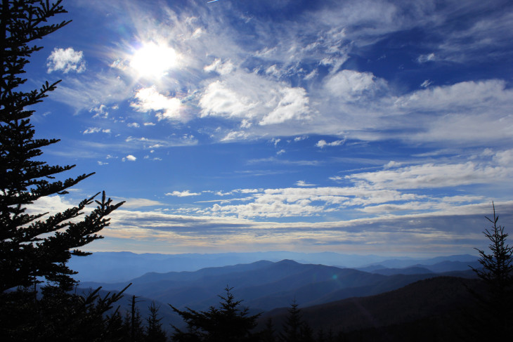
There are two ways to get to the top of Clingmans Dome and both include a breathtaking drive that drops you a short distance from the top. One route is via a virtually straight up paved walkway where everyone over 50 wheezes their way to the top. The other is a small trail called Clingmans Dome Bypass Trail. Reached by short stretches on Forney Ridge Trail and the Appalachian Trail, it’s a little over a mile each way, but it takes you into the woods. When the trees part you thank God, Buddha, Zeus and all things holy that you are standing on that trail, at that moment. You also realize you are alone.
VIEW FROM CLINGMANS DOME. IF THERE WAS AN ACCOMPANYING SOUNDTRACK TO THIS PHOTO, IT WOULD BE ME DROPPING TO MY BONY KNEES AND GIVING THANKS.
ON THIS DAY, THE SUN WAS PLAYING HIDE AND SEEK BEHIND THE CLOUDS. YOU COULD HEAR THE TREES COUNTING TO 100.
Smokemont Campground is a short distance from the Oconaluftee Visitors Center, which borders an old settlement and a large meadow where elk come to graze each evening. You can also pick up the Fork Trail and hike along the Smokemont Loop, which isn’t a loop, unless you include a portion of the Bradley Fork, which I did not. For some reason in Great Smoky Mountains National Park the term loop is used on maps and on trail signs, when many times a ‘loop’ is made up of several trails combining to form a loop. In any case, the hike took me through a beautiful section of maple, dogwood, and poplar trees, as several switchbacks rose to the northeast slopes of Richland Mountain. This was not an easy climb. But sometimes finding the sound of a river and the wind sneaking through the last of fall’s brittle leaves takes a bit of work.
THIS IS THE SECOND ANIMAL ON MY TRIP THAT HAS GIVEN ME THE STINK EYE
IN THE SMOKIES, SOMETIMES YOU JUST TURN A CORNER AND THIS IS STARING AT YOU. A GREAT MOUNTAIN WITH SLOPING SHOULDERS FOLDING INTO THEMSELVES.
AS I WAS LOOKING DOWN AT THE WATER RUSHING PAST MY FEET, A SMALL VORTEX BEGAN. I WATCHED IT FOR SEVERAL MINUTES AS ITS CENTER GOT TIGHTER AND TIGHTER. PURE LUCK I FOUND THIS. PURE LUCK.
PIGEON FORGE IN ONE PHOTO. I HAD THEM MAKE ME A TSHIRT WITH BUTTERFLIES ON IT THAT SAYS ‘I LIKE DOLPHINS’.
THIS IS A TEST. I WAS TAKING A PHOTO OF ONE ROCK IN PARTICULAR. WHICH ONE? MY EMAIL IS LCSMITH@THEMOUNTCO.COM. IF YOU GET IT RIGHT I WILL SEND YOU A PRIZE.


